


Lugnaquilla mountain sits at an elevation of 925m and is the highest mountain in County Wicklow and the province of Leinster. Lugnaquilla is also the highest mountain outside of County Kerry. We hiked Lugnaquilla mountain from the Wicklow side of the Glenmalure valley. The village of Glenmalure is steeped in history and has a scattering of monuments erected to celebrate heroes of battles by the locals to defend against the English army back in 1580 and the 1798 rebellion.
Lugnaquilla Hike from the Glenmalure valley
The main reason we are hiking Lugnaquilla from the Glenmalure side of the valley is that this is the first mountain that I (Paul) ever hiked. I would class this as my local mountain. I grew up and lived very close to this mountain.


Key Lugnaquilla Facts
- Hike Length- 6.6kms each way, 13.2km total
- Lugnaquilla Height- 925m Highest Mountain outside of County Kerry
- Lugnaquilla starting point- Park here on the side of the road
- Is the route signposted- No signposts or route markers
- Is the route clear- Yes in places but very easy to lose track of your location
- How hard is the hike? 6 out of 10
- Is Lugnaquilla dangerous? Yes large drops in many places
- How long to Hike Lugnaquilla- 5-6 hours
Starting our Hike up Lugnaquilla
We parked our car on the side of the road opposite the red galvanised roofed cottage underneath the waterfall and the zig-zag trail. There isn’t much room to park cars here so come early and keep your car tight to the ditch. Luckily we started our hike early, so we had a selection of parking spaces.
We took out all our hiking bags from the car and packed our windbreakers as we know Lugnaquilla has a very flat high point and is very exposed to strong winds for a much longer distance than every other high point. As it was extremely sunny and still early in the morning we all applied factor 50 suncream (I forgot the back of my legs) and walked back up the road toward the little laneway down to the small house with the red roof.


Lugnaquilla Trail
We walked down the lane toward the red-roofed house passing over a concrete bridge, when we reached a small river we kept left here and walked up beside the fence on our left-hand side. We followed the sign for the Zig-Zag trail and walked over a small timber footbridge.

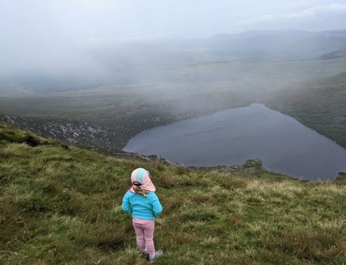
We followed the grassy trail which zig-zags up the side of the hill pretty quickly. The trail rises in altitude very quickly and nearly instantaneously we found ourselves rising up over the valley and we could see the magnificent views down the middle of the U shaped valley.


When we reached the top of the Zig-Zags the nice grass footpath disappeared and from here on hiking boots are required to complete the hike.
This section of the Lugnaquilla Hike is well walked and very easy to follow. From this point on it becomes a little harder.
Trail Markers
Turn right after the large warning sign. No other markers were present on the trail.
At the end of the trail, we continued up the hill to the RHS. The ground started to get slightly boggy and the footing started to get slippy at this section.


There are no clear markers from here.
We walked for about 5 minutes until we met a sheep fence and a sty to cross over. Make sure to cross over the sty, as the trail is visible and in front of you from this point.
From here we could start to see some rock formations and the hiking trail goes up over the ridge to the side of the mountain. The hike up Lugnalquilla starts to evolve from walking up a hill to a bit of a scramble over rocks and heather.

From this point, we lost all the lovely views of the valley behind us but we started to get amazing views down either side of the ridge which we were walking up along. We felt that this is probably the toughest part of hiking up Lugnaquilla, it is definitely the steepest of all the sections. After lots of small detours to find the safest route along the steep rocky edges, we reached the top of the ridge.

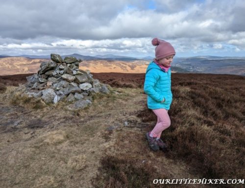
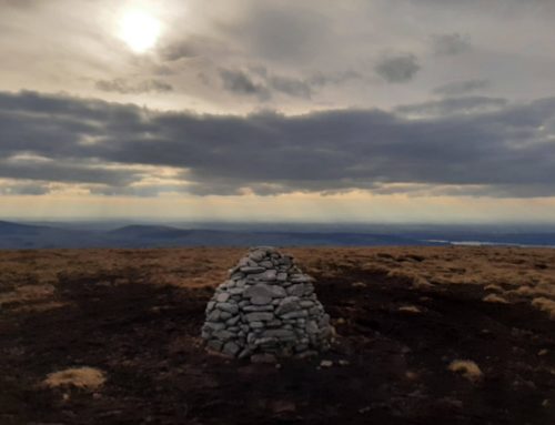
Cloghernagh Stone Cairn at 783m
The top of the ridge is marked with a large bundle of stones and is the Clogernagh summit. This marker will come in extremely helpful when we are descending, as we will know to aim for this on the way back down to the Zig Zag Trail.

The steepest section of the hike is now over.
From this point, we were now high enough to see all the surrounding mountains that include, the Sugarloaf, Turlough hill up over Glendalough, Kippure (Dublin’s highest point) and I’m sure we could also see Mount Leinster too, which was looking south back down toward Carlow.


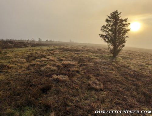
The top of Lugnaquilla is different from all the other County high points that we have hiked, as the top is not a big pointy mountain like the rest, but it is a reasonably flat top with a gently sloping climb to the top.
Lugnaquilla Summit Route
The trail on the top is through heather and is not greatly marked. Have a map handy because there are cliffs on either side of this mountain.

When we started walking we could see a vague trail going in the direction of the top of Lugnaquilla.
There are a number of national wildlife trust signs and post along the trail and the path seems to follow the signposts along the top of Lugnaquilla.


We finally came to the base of the hill before Lugnaquilla summit but it is not too steep and is easy to walk up to the top of it. The path reaches the top of the hill and we can see the Cairn to our left-hand side of the hill.
At the top of the gentle hill, we turn left and walk along the tight windswept grass toward the top of Leinster and Wicklow’s highest point, Lugnaquilla mountain.

Like clockwork Ourlittlehiker fell asleep about 30 minutes before we reached the top of Lugnaquilla, so we had to be very quiet trying to take the County high point pictures. Lugnaquilla seems to get big crowds of people up on the summit.
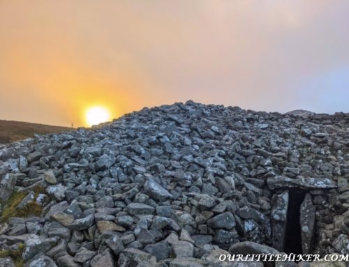
Lugnaquilla Summit Cairn
When we reached the top of the Cairn, there were about 20 people getting shelter from the wind and eating their lunch. We did not stop at the top as we felt this was one of our easiest hikes and we said we would treat ourselves to a nice lunch on the way home (maybe even an ice cream).


Ourlittlehiker woke up just as we were leaving the top of Lugnaquilla, so we had a good game of, spot the sheep on the way down and a sing-song. Thankfully, Ourlittlehiker did not get my poor eyesight, as she can spot a sheep miles away but all I can only see is white fluffy dots in the distance, so I have to just play along.

Descending Lugnaquilla
We walked an out and back route for this walk.
Coming down from Lugnaquilla we aimed for the pile of rocks at the top of Clogernagh. While descending the ridge we got some amazing views of Fraughan Rock Glen.
The minute we started our descent the wind stopped blowing and I realised instantly that I missed my calf muscles with suncream (that’s going to hurt tomorrow).

Halfway down the zig-zag trail, Ourlittlehiker wanted to stretch her legs so we took her out of her backpack and let her walk the lowest section while holding her Mams hand and a walking stick in the other hand (how cute). She loved walking along picking the grass and then we crossed the footbridge again and she loved looking at the water flowing under the bridge.


Lugnaquilla Map
Our thoughts on the Lugnaquilla
Lugnaquilla is one of the highest mountains that we have climbed and it is only 113m lower than Carrantuohill, the highest mountain in Ireland. We felt that our Lugnaquilla hike was not that hard of a hike and we have found that some of the much lower mountains are harder to hike.
There are sections of the Lugnaquilla hike, that requires good navigational skills, especially if the weather turned bad. Lugnaquilla is different from most of the other County high points, that we have climbed previously. Most of the difficult sections of this hike are at the bottom section of the mountain and the top of the mountain is generally flat with gentle gradients to reach the top.
This is my fifth time to hike Lugnaquilla and Gina has done it twice previously but it was Ourlittlehiker’s 1st time and she got an amazing day to hike wicklows highest point.
We hiked up to Lugnaquilla and back to the bottom in 5 hours, there were a couple of stops for snacks and drinks along the way.