


Trostan Mountain is County Antrim’s highest point and the summit sits at an altitude of 551 meters. As County Antrim’s high point is only 551m we decided to do all our sightseeing in Northern Ireland before we hiked this county high point. We left our house at 5 am and drove 4 hours to reach the Carrick a reed rope bridge to explore nice and early before all the large crowds reached the attraction. We then drove to the Giant’s Causeway and did the cliff loop walk and generally explored the whole area.
After doing all the above exploring, we decided we should really make our way to the mountain, after all, that’s the reason we were up in Northern Ireland. We plugged Trostan’s coordinates into Google maps and we were within 1-hour drive away from the mountain. The driving route to Trostan was very scenic and filled with small roads and lots of sheep.
The hike up to the summit of Troston follows the Ulster waymark trail signs the whole way until it meets a fence. We crossed the fence and turned left up toward the top of the hill until we reached a 3-way junction of fences where we crossed onto the other side of the field and hiked up to the county high point. We found this county high point a lot harder than it should have been, as we basically tried to cram too much into one day. The hike is slightly boggy so make sure your boots are waterproof and you have gaiters on.
Parking to hike Trostan County Antrim Highest Point
We parked our car in a small car park area on the side of the road just where the Ulster way cuts back in toward Trostan mountain. Just as we were packing our bags and preparing Ourlittlehiker in her backpack, a local farmer drove up beside us for a chat. The local farmer was interested to hear that we were from County Carlow/Wicklow, the farmer had never heard of Glendalough but surprisingly enough he knew a village right beside our own village that had a tiny population because he had delivered cattle there previously. It’s a small world!!!


The parking area that we used to hike Trostan is very small, you would be lucky to get 2 cars here. There was a large H Sign monument made out of stone on the other side of the road. This is where we started our hike up Trostan.
Hiking Trostan Antrims highest point
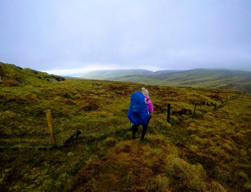
We walked down beside the H sign and followed the Ulster waymarkers. We could see that the hike was heading towards a footbridge over a small stream about 200m away. Straight away we noticed the ground conditions were very damp and boggy. Under every footstep, we seemed to sink into the bog.


The footbridge was a nice little addition to walk over the stream, we don’t see many little features like this. We crossed the stream and nearly immediately the ground became even wetter if that was possible. The boggy ground was starting to make this mountain feel a bit like a slog. Every step we took it felt like we were sinking even further into the soft peat and we had to lift our knees even higher to clear the ground level.
We quickly became good at spotting soft spots, these were generally a bright green colour. We walked into one of these at the start and nearly went down to our knees in it.
We crossed numerous little streams and waterlogged sections of land, while still following the waymarker posts. The trail was gradually rising to meet the bottom of Troston. When we reached the bottom of Troston, the trial rose up to the right and thankfully out of the boggy section of the hike.


From here our increase in elevation started at a gentle pace. The path skirted up around the hill but the hike seemed a lot easier as we weren’t tackling the boggy heavy ground conditions anymore.
We eventually reached the section of the hike where we left the Ulster way hike. The Ulster way hike turns right at the fence but we cross the fence and continue up the hill following the fence and keeping it on our left-hand side. We didn’t follow the exact line of the fence, as the ground near the fence is very poor. We kept an eye on the fence on our LHS but we cut through the heather field, finding better walking ground.


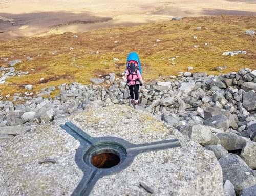
We then came to another fence T junction, we crossed the fence here again in the direction to walk up toward the peak of the hill. This fence did not have a Stile, so care should be taken here not to do damage. We could see an arrangement of stone in the distance, from here and we taught it was Antrim county high point but unfortunately when we reached it was only old stones that looked like ruins of an old house.


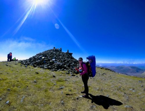
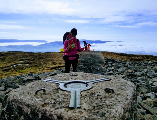
From the Stone ruins, we could see the Cairn of the county high point in the distance. We had about 300 meters to walk to meet the cairn. The ground conditions on the top of Trostan were barren, to say the least, and even resembled a moon-like surface. We enjoyed walking along the top of Trostan, as we weren’t walking in water anymore and the views were amazing. We could even see all the other county high points from the top that we had already climbed.


The cairn on Trostan is totally different than all the other county high point markers. It is elevated over 2 meters on a large pile of soil, it nearly looks like the soil was placed here to help with an elevation gain.
Our thoughts on hiking up Trostan Mountain
The hike to the top of Trostan started out bad for us, as we hate getting damp and dirty legs and boots. The ground conditions eventually improved and so did the views. Trostan was an interesting County high point, it gave us a taste of the Ulster way as we are essentially long-distance hikers at heart.
The summit of Trostan was a very nice area with lovely panoramic views but in the back of our minds, we were always thinking about our return walk along the same boggy patch of land that brought us to the top.


Which county Hight point after Trostan hike
We plan to hike Sawel mountain tomorrow morning. Sawel is the county high point of Tyrone and Derry. Sawel mountain is on the Sperrin road and is only 45 minutes away from our night’s accommodation.
