
Mount Errigal is the highest point in County Donegal. The mountain sits at an elevation of 751 meters. Errigal is one of these mountains that looks different in shape and scale depending on the direction that you approach it. Errigal is part of the Derryveagh Mountains and is locally referred to as one of the seven sisters.

Mt Errigal Key information
Hiking Mount Errigal (First Attempt)
It took us 2 attempts to summit Errigal. We have to be extremely cautious with exposed peaks like this mountain because we are carrying a baby. On our first attempt, we walked through the bog section and decided to stop, just before we reached the loose gravel path. The weather became very wet, cold and slightly windy on our first attempt to hike mount Errigal but the forecast said it would pick up, so we decided to attempt the hike while hoping the weather would improve. Unfortunately, the weather did not improve and we decided for safety reasons to return another time.
On the second attempt, the weather forecast was for an overcast day with chances of showers. Thankfully, we summited the mountain and returned back to the car within 3 hours. We got amazing views and outstanding weather conditions.
Getting to Mt Errigal
Errigal is about 2 km from the town of Dunlewy, there are no footpaths or local transport available to the mountain. We did see people walking from Dunlewy Hostel but take care as the road is very busy.
We left our home in Carlow at 6:30am and drove for 4 hours 30 minutes to reach Mount Errigal. On our first attempt, we were camping in Killybegs which was 1 hour 30 minutes away.
Mt Errigal car park
There is a small carpark at the base of Mount Errigal, which is able to accommodate about 10-15 cars.

Even though we reached the car park at 11 am, it was totally full. We parked on the side of the road with lots of other cars squeezed in beside us. The side of the road parking seemed pretty safe.
When we stopped the car, we all sat there eating and refueling before our hike to the summit. After our breakfast, we changed
into our hiking gear, we were surprised to see lots of people walking in jeans and trainers.
Hiking Mt Errigal (Attempt 2)
As we already attempted to hike this mountain once, we knew which direction we were walking. We saw lots of people walking the shortest route to the start of the scree and we did this the last time too but this time we decided to walk a slightly longer route following the river, as there is a nice clean path the whole way until we reached a pile of stones, from here we then crossed the bog toward Errigal to the start of the scree.


We are now past our previous turnaround point, and the weather was lovely, there was a slight wind but nothing to worry

Mount Errigal path
about. When we initially stepped onto the scree it felt very similar to Croagh Patrick. Every step we took, it felt like we slid back down two more steps. Thankfully this didn’t last too long and the path became easier to walk on.
From here the path cuts up the ridge of the mountain while increasing in height pretty quickly. The path is very slippy and good walking boots are essential. The walking route quickly rises and pretty quickly we are level with the neighboring mountain Mackoght, which is also called little Errigal.


We start to think that we have reached the top of the mountain, as we can see a top point now. After climbing 29 high points, we have learned this foolish lesson the hard way and checked our Viewranger app to see that we still have 100m to climb vertically and a long ridge section to the summit.
The trail walks around to Mackoght side underneath a ledge. There are steep drops to the side here and care should be taken. Thankfully we were fully sheltered from the wind and we also didn’t meet anyone while on this tight ledge.


When we reached the top of this section we could finally see the summit of Mount Errigal. From this angle, there looked to be 2 peak summits but our research before the hike said that the first peak is the highest point in County Donegal so that’s the high point, that we are after.
We continue climbing upward from here but not at such a steep angle. As the mountaintop levels off slightly, the ridge becomes thinner and there are steep drops on either side.
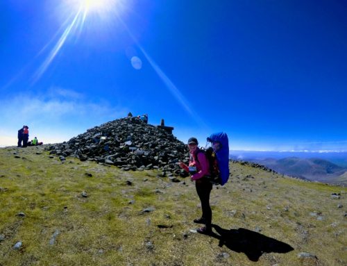
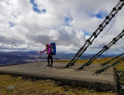
When we reached the summit of Mount Errigal, there was a large crowd on top of the peak. We waited for 5 minutes to try and capture a quick photo of the summit on our own, which we thankfully got before another large crowd ascended onto the high point.


We walked along the thin one-man wide ridge, to the other peak which is only 2m lower than the other peak but unfortunately, we couldn’t get any nice pictures over there due to the large crowd.


We quickly started our descent to the bottom of the mountain. Thankfully we were prepared for the poor footing and had our hiking poles ready for the descent.
Our Thoughts on Mount Errigal Hike
Mount Errigal looks like an extremely hard mountain to hike, as it is quite steep looking on all elevations. The most difficult part of this hike is the loose scree on the ground, which makes footing very tricky. The path through the bogland isn’t fully visible and can be hard to navigate if there is heavy fog.
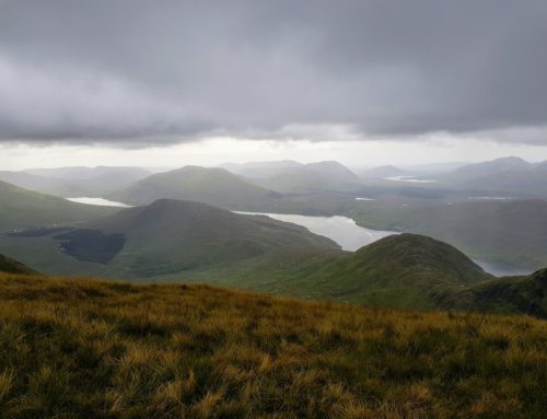
The views from Mount Errigal, are simply breath taken and well worth the hike to the summit, we really enjoyed this hike and highly recommend it.
We recommend that you bring good hiking boots and poles as we saw many people slip throughout the hike.
Mount Errigal Walk Time
Mount Errigal can be summited very quickly, we hiked to the summit and back to the car in 2 hours 50 minutes, which is pretty good going with a toddler on our backs. We only had a few short stops for water and photographs.
The views from Mount Errigal are simply breath taken and well worth the hike to the summit, we really enjoyed this hike and highly recommend it.
Mt Errigal Map
