


Getting to Moylussa Co Clare
Moylussa is the highest point in Co Clare and the summit sits at a height of 531.6m. The trail that we used to hike Moylussa started beside the village of Killaloe. Killaloe is a small village that sits on the shore of Lough Derg and the River Shannon.
When we inputted the coordinates into the car sat nav, we were 2 hours 35 minutes drive to the start of our Saturday morning hike. We all woke at 5 am and left our house in Co Carlow with the expectation to arrive at Lough Derg around 8:30 am. As it was a Saturday morning on a bank holiday, we met no traffic and flew down to the start of the Moylussa hike for 8:30. When we reached the starting point of the Moylussa hike, we sat and had a lovely little breakfast picnic looking over Lough Derg.
A part of the Moylussa hike follows some of the East Clare way. We always love getting a taste of all Ireland’s long distant waymarked trails.
Moylussa Key Facts
- Walking time to Moylussa top- 3 hours 30 minutes with breaks
- Distance to the summit- 10 km
- Amenities- Yes there is a scatter of seats along the route
- Difficulty- Not very difficult- 4 out of 10.
- Signposting- There are signposts but for a number of different hikes and slightly confusing.
- Hike Quality- Nice hike but it was foggy when we did it. 5 out of 10.
Starting Hiking Moylussa
The start of the Moylussa high point hike starts in the Ballycuggarn forest. We parked our car down in the car park beside Lough Derg, as we wanted to walk Ourlittlehiker around the lake to let her see the Ducks before we started our climb to the top of Moylussa.


We started the hike by crossing the busy road, to enter Ballycuggaran forest (take care on the road it is extremely busy). We walked up into the woodland on the forestry access road which has a rough hardcore surface. After about 3-4 minutes we reached the start of a lopped walk and another car park area but the road up to this point is a little bit rough and we saw a few cars struggling to drive up to it. At the yellow barrier, we followed the loop walk up to the top corner of the wood.


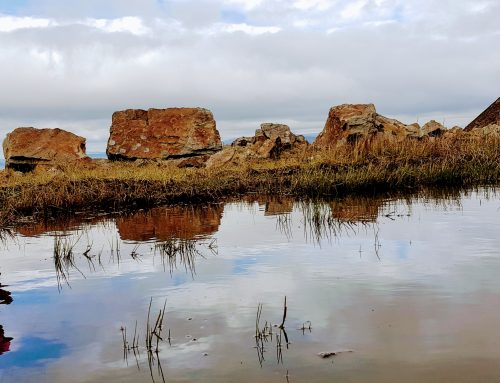
The woodland trail initially cuts up through a mature wooded area which provided us with shelter, as it was raining and foggy when we started our ascent to the top of Moylussa. We didn’t get many views of Lough Derg until we walked out of the forest trail and onto an access road for timber lorries. The view of Lough Derg even on a misty day is impressive.


We crossed two timber lorry access roads but we continue following the looped walk trail while walking uphill. The trail has a small bit of damage from water erosion due to our harsh winter this year. It made a pleasant change to be walking in a green woodland area rather than an open windy mountain.
The trail eventually leads up to a lorry road, which we followed around Feenlea Mountain. We could now see the base of Moylussa mountain but unfortunately, most of the mountain was covered in fog.

The forest is in the process of being cut down and we had views all around Lough Derg from this point. I assume this road is very busy during the weekdays with timber lorries moving all the cut down trees.

Follow the Moylussa Sign
Just as we walked around the back of Feenlea Mountain we saw two signs of Moylussa pointing down the hill at the Y junction. We followed the road which dipped down into a hollow and rises up again until we found another sign pointing up a narrow trail through another forest. This trail is cut into the clay bank on both sides.

The fog was still pretty thick at this stage and the higher we rose the thicker it got. The trail started to become extremely steep from this point, we were walking along and out of nowhere (due to the fog), we saw an extremely steep hill in front of us leading up toward a gate. The trail leads towards the gate, then it seems to circle around the gate to the right. The ground is now really slippy due to the crushed shale stone and it doesn’t provide great footing, especially on the descent back down.


The hardest section of the Hike
We follow the zig-zag trail up the steepest section of the hike to Moylussa. This section is the toughest section of this whole hike, so a pretty easy hike overall. It is a pity that it was so foggy on the day that we climbed Moylussa, as we imagine the views on the ascent would be very impressive.


Moylussa Boardwalk Sections
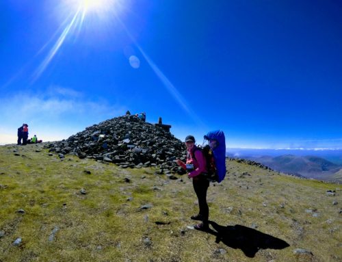
At the top of the zigzag road, we were greeted by timber steps up onto a new railway sleeper boardwalk. The boardwalk was placed on the top of Moylussa mountain to help keep the hiker’s feet reasonably dry. We walked along the top of the boardwalk until we reached a stone at the top of the mountain with 1748ft marked on a plaque.


Finding Clare County High point
The version of our guidebook is an old one and it doesn’t mention this stone as the high point so we decided it would be better if we follow the guidebook to find their high point. We walked to the rear of the large stone toward the wire fence and then followed the fence up the hill.
The fence follows a very boggy peat road that is very soft so take care here as we were crossing it once and I went down to the knee in one section (very funny, but slightly frightening). We followed the fence up toward the highest point of Moylussa, until a corner in the fence. We then took out our Viewranger app and found the exact high point of 532 which had no distinctive marks at all.
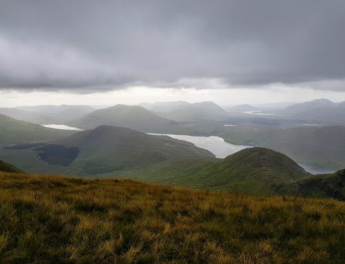
We then followed the fence back down to where it met the start of the boardwalk. As we descended the fog started to clear and we finally got a nice view of Lough Derg in the distance.

Map of Moylussa Hike

Our verdict on Moylussa Co Clare high Point
We climbed to the top of Moylussa and back down to the bottom in 3 hours and 30 minutes, this included a few small stops and breaks for water drinking along with Sheep, Cow and Cuckoo spotting. If you allow 3-4 hours you should easily do this hike.
This was an enjoyable hike and we imagine it would have been much better if it wasn’t raining and foggy. This is the third time we have hiked a county high point in foggy conditions and we always find it mentally harder.
We plan to come back again someday and climb Moylussa mountain as we want to see some of the amazing views we missed this time.
This is a very nice and easy hike. No major navigation skills are required here unless you try to find the exact high point like us but you will need an OS map and compass or the Viewranger app to do this.