


Slieve Foy or is also spelt Slieve Foye, is the highest point in County Louth and has a summit elevation of 589m. We climbed Slieve Foye from the County Louth town of Carlingford. It’s rare to start walking a county high point from the centre of a town. This is the best route to climb Slieve Foye as you can get some lunch and admire the beautiful town after the amazing hike.
We parked our car on the side of the road beside the sea, its free car parking here so no need to worry about being clamped. We started our hike at 11am and returned back to the car at 3pm. The hike up Slieve Foy is a very pretty hike and gives amazing views over the Cooley peninsula from the top on a clear day. The track initially follows a small country lane that is very similar to a Camino de Santiago hiking trail, the hike then follows a grass path up over the ridge of the mountain. The ridge and trail to the top of Slieve Foy is very safe and the trail is very easy to follow. This is a very rewarding hike and not too hard, we met numerous other families out hiking Slive Foye the same time as us. We had a lovely picnic at the end of the hike in Carlingford and Ourlittlehiker didn’t want to sit down to eat, all she wanted to do was explore the lovely area.
Getting to Slieve Foye
County Louth’s highest point is situated in the town of Carlingford. We parked our car in a free car parking spot beside the sea. This is definitely one of the prettiest towns that we have started hiking from on our county high point challenge. Thankfully Carlingford is very easy to access from the M1 motorway and it only took us 2 hours to reach for our bank holiday Monday hike. Try to allow additional time to explore Carlingford as it has some amazing little tourist sights to potter around.
Start hiking Slieve Foye
We left the car park and walked to the rear of it in the direction of Slieve Foye mountain. We walked under the stone archway and down the pedestrian street. When we reached the one-way road leading up the hill we followed the roadway straight up the hill out of the town of Carlingford. The road leading out of the town is a small cul-de-sac road leading to a group of private houses.


The road initially passes a high curved road/wall and then past a number of modern houses on the right-hand side. The road then comes to a crossroads and the track to Slieve Foye transforms into a small country lane leading upward between two fields.


At this point, we are starting to rise in elevation and when we turn around we are greeted with amazing views of Carlingford. The small laneway is very tight and slightly overgrown but this adds to the appeal of the hike. We had to be careful with Ourlittlehikers legs as some of the wildflowers had sharp thorns. The ground on this section is slightly tricky as there are large stones scattered underfoot and good hiking boots are required for this section or you could easily twist an ankle.


The trail cuts between the fields, which have loads of sheep and a horse, Ourlittlehiker loves all animals, so we spent about 10 minutes talking to the animals as Ourlittlehiker had full-blown conversations with them.


At the top of the gravelly lane, we reached a metal stile to cross a fence and into a field at the bottom of Slieve Foye mountain. We could see a path worn into the grass rising up the hill to the left of Slieve Foye. The walking trail cuts through ferns and at this stage of the hike is following the Commons loop up to Slieve Foye. The hiking trail continues through the middle of a large section of gorse bush where we meet a T junction on the trail.


We took a right here following the red trail arrows up the hill. At the top of the hill, we see another sign with a red arrow and take a left here following the signposts.


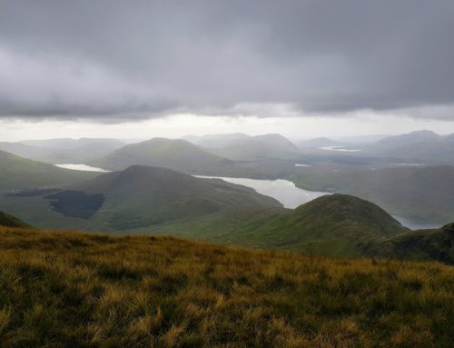
From this section, we have a good view of the trail that we are going to use to get to the Col between Slieve Foye and Barnavave. The path sweeps up along a nice gentle grade toward the Col of the two mountains. This is a lovely part of the hike up to Slieve Foye, as the path is wide enough to have a nice chat while walking up the hill slowly but we also have great views of the sea below the mountain.


When we reach the col we came to another T Junction, Slieve Foye is to the right and Barnavave mountain (350m) is to the left. The trail leading up to Slieve Foye isn’t as obvious from here but we can see signs and a trail leading up between 2 faces of rock toward the ridge of Slieve Foye.

While hiking toward to base of the ridge, the hike looked very steep but when we reached it, the trail was very wide with good footing and it was not too steep. We quickly reached the top of the passing between the two rock faces.


From here we follow the trail up to the right which passes around rocky areas which are not walkable. This section of the trail cuts back over to the front side of Slieve Foye and provides a spectacular view of the bay below. The trail is not too difficult and keeps away from steep drops to either side.


When we started hiking Slieve Foye the weather was overcast but mild, just as we reached the summit of Slieve Foye the weather got really warm. It was the first of all the peaks that the air felt warm and we could relax without worrying about getting cold. Just as we were about to summit Slieve Foye, Ourlittlehiker decided she wanted her shoes and socks off. So we stopped and let her feet breath in the lovely warm summer air. We all took this opportunity to top up with suncream as the sun had just broken through the cloud.
Slieve Foye Summit
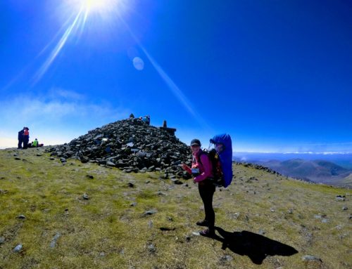
The summit of Slieve Foye is spectacular and definitely, in a league of its own. It has amazing views of the Sea right below the mountain which no other county high point (that we have climbed yet) has this type of amazing views and if they did, we probably missed them due to fog.
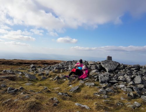
The summit of Slieve Foye is marked with a concrete Cairn on the top of a large rock. It is tricky climbing up to the cairn on the rock. We left Ourlittlehiker at the bottom of the rock with her mammy and Dad climbed up to the Cairn to get some elevated photographs of the amazing Slieve Foye and Cooley mountains below. From the top of the Cairn, we could see the other Cooley mountain and Carlingford walks.


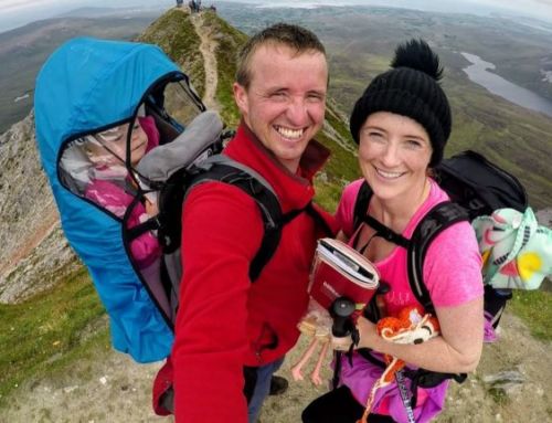
Just as we were leaving the summit we met two other families with small kids, it so refreshing seeing families on these mountains, especially very accessible mountains like this. The route we used is the best way to summit Slieve Foye and is very safe.
Descending Slieve Foye
The hike down Slieve Foye was done very quickly, as the ground conditions on the mountain were extremely good. Maybe we got a little confident of the good hiking conditions and dad was probably being complacent and walked right into a boggy section of the trail and got mucky boots and legs for himself.
When we returned to our car we set up our picnic in the park underneath a tree for shelter from the sun. Amusements had been set up along with chipper vans for the bank holiday weekend. We had already packed a healthy picnic but the minute you smell chips its hard to think of anything else so we decided to get a bag of chips and a sausage to share between the three of us with our picnic.
After our picnic, we explored the lovely town of Carlingford where we got some homemade ice cream to finish off a lovely day.


The verdict on Slieve Foye
Being honest we were tired after all our hiking lately and we left our house this morning slightly torn on our choice of the hike for the day, as it was over 2 hours to drive to Slieve Foye. After we summited Slieve Foye, we all agreed that we made the right move by hiking this amazing mountain. This was the hike that we needed to lift our spirits again, as anyone that is doing the County high points challenge will know that hiking the CHP isn’t the hard part of the challenge, its the driving to all these remote places in Ireland (average 4 hours each way) that is the tiring part. We passed Carlingford many times going to other high points and we probably should have tried to fit it in with some of these hikes.


This hike is easily in the top 5 of the best hikes in Ireland for us and definitely one of the best county high points to hike. We loved it and so did Ourlittlehiker but I assume it was the sheep and horse that she liked.
Slive Foye Hike Map
Maps and more information about Slieve Foye can be found here