


Truskmore Mountain is the highest point in County Sligo and County Leitrim. Truskmore is part of the Dartry Mountains. The Dartry Mountain range also includes Benbulbin and Benwhiskin. Benbulbin has a distinctive shape formed through Glacier movement during the ice age.
Truskmore mountain has two county high points on the summit. County Sligo high point is beside the TV mast compound and sits at an altitude of 647m. Leitrim’s county high point is about 200m away from the TV mast and on the edge of a steep vertical drop and sits at an altitude of 631m.
To reach Sligo and Leitrim high points was a very easy hike. We just had to follow the mast access road to the summit of the mountain. Leitrim county high point was slightly trickier. On the summit if you are standing with your back to the TV mast compound and Sligos highest point is to your left, then Leitrim’s high point will be to the RHS past the boggy area. Care should be taken here in fog as there are large cliffs right beside Leitrims high point stone marker.
Driving to Truskmore Mountain
The access road to the TV mast that is used to climb to the Summit of Truskmore mountain is located on the Gleniff Horseshoe driving loop. The looped drive brings you underneath the bottom of Truskmore and along the bottom edge of the valley. If time allows, there is an old mill along the loop that is a perfect location for a small picnic area. When we reached the RTE Tv mast access road we noticed that there is limited space to park our car safely. We squeezed in beside the gate on the edge of the road and the grass ditch. There is only enough room here for 1-3 cars maximum, so come early.


We arrived at around 9 am to start our hike. We were only on the road for a few minutes and about 4 cars passed us driving up to the summit of Truskmore. One of the workers even stopped and asked us did we want a lift to the summit. Maybe they felt sorry for two very pale people carrying a baby on their back up a massively steep hill in 25-degree heat. Obviously, we said we were here for the walk but thanked him for asking.
Hiking Truskmore Mountain County Sligo and Leitrim highest point
We recently took a small break from hiking for two weekends, as we felt all the driving in between all the mountains with a toddler was really tiring us out. Over the past two weekends, we stayed at home and done loads of house chores that were being neglected because of our hiking hobby. While we were home, not hiking, we got our hands on an old campervan and done a small restoration. We decided to do a small retro campervan holiday, see here. After our break from hiking we both expected to feel really unfit and sluggish but the minute we put on our hiking gear and started walking on the road, we all felt refreshed and ready to hike. Maybe the break was a good idea.

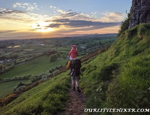
To start the hike, we climbed over the TV mast gates. We used the gate design as a ladder and climbed over the top of the 2m high gates. Ourlittlehiker is growing up extremely quick and we are seeing changes daily at this stage. There was a stage where she would find her Deuter hiking bag and try to get into it to go hiking but at the start of this hike. She didn’t want to get into her bag today. As there was a good road surface on this route, we decided to let her walk until she wanted to get into her hiking bag.


She walked up the road for about 150m and then she got tired and looked to get into her backpack. I think she wanted to get a better view of the sheep, she calls them ‘Baaaas’. She shouts as loud as she possibly can the minute she sees them, it’s very funny.


The road to the summit of Truskmore zig-zags up the side of the mountain and is a very easy walk. The hike is not too steep and cuts through the edge of the mountain. On the ascent to the top of the mountain, we pass through unused livestock grates. The road curves around to the side of Truskmore and then the ascent angle increases significantly with tighter zigzag patterns up the road.


We finally reached a point on the road that we could see the TV mast compound, from here it felt like a Sunday stroll. At this stage of the day, the sun was extremely hot, we expected a bit more wind on the summit but there was no more than a small summers breeze. We took out our hiking umbrella and put it over Ourlittlehiker to help keep her covered in the shade. The umbrella worked a treat and she loved it.


When we reached the TV mast compound, we walked around to the rear using the RHS footpath. We immediately saw the County high point Cairn marker underneath some large cables used to secure the antenna. We relaxed here for about 30 minutes, as the county high point was shaded by the large antenna above.
While we were relaxing in the shade, a group of workers started to use the wire elevator to go to the top of the antenna. Ourlittlehiker loved looking at the antenna workers, they were all waving to her, it was so cute. One of the workers came over to us and said that they had never seen anyone use an umbrella on the mountain, he said, there is usually gale force winds up there, and “after 40 years of working up here you get to see everything”, we had a good laugh at this.


After looking at the brave workers on top of the antenna, we decided to leave them alone and walk over to Leitrim’s highest point. We walked over to the other side of the compound and took out our Viewranger app and could see that the county high point is over near the cliff edge. We walked in the direction of the high point while trying to navigate through the boggy peat. It’s amazing that this area is still boggy as we are in the middle of a heatwave and a drought. This summit must be extremely boggy throughout winter, so take care.


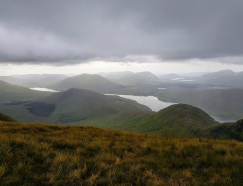
We reached Leitrim’s county high point which is marked with a pile of stones on the edge of the cliff looking over Sligo and Leitrim. There are some pretty impressive views of the plateau below. We returned back to the road and walked back down toward the car looking out for sheep on the descent.


Our Verdict on Truskmore County Sligo and Leitrim’s highest points
This is another easy access road hike to the summit of Truskmore. It is probably the toughest access road hikes out of all the county high points. The only area that requires navigation on Truskmore is the Leitrim part but on a clear day, it should be very easy to find.
The Sligo Cairn has nice views over the Daltry mountains but the antenna wires ruin them slightly. Leitrim’s highest point is right beside a cliff edge, so take care here. The views from this section are amazing and worth sitting and taking a break to admire them.
We hiked to the top of Truskmore mountain under 1 hour and returned back to the car in around another hour. We took lots of breaks in the shade and drank lots of water.
Overall this was a nice easy hike, just take care when parking the car and trying to find County Leitrim’s high point.